MEMPHIS, Tenn. — Local law enforcement plans to be out in full force over the next few days to ensure travelers get to their holiday destinations safely, but there’s also a new tool drivers can use to try to avoid accidents.
Thanksgiving, and the days surrounding it, is one of the busiest travel periods of the year, and the Tennessee Department of Safety and Homeland Security wants drivers to be prepared before they get behind the wheel.
This is the first year Tennessee travelers can use the Interstate Crash Hot Spots map. It shows every interstate across the Volunteer State. Drivers can zoom in to their specific city, like Memphis, and see where the most interstate crashes occur.
The most problematic areas in the Bluff City involve the intersection of interstates.
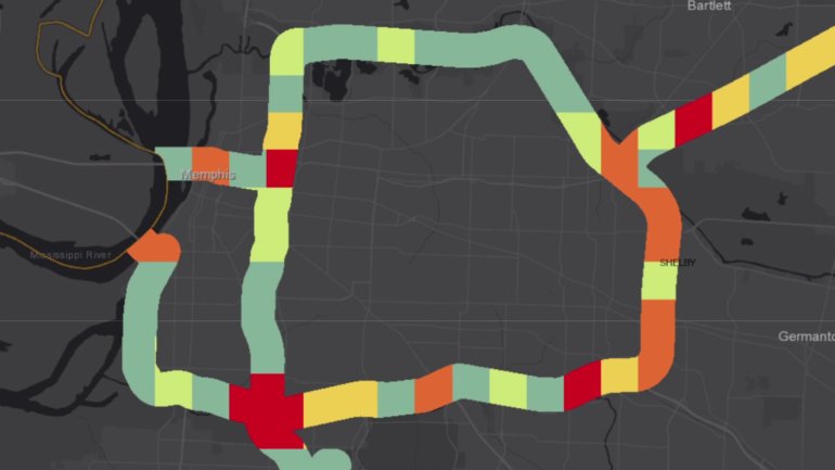
Two of the most dangerous areas for interstate crashes in West Tennessee are in South Memphis where I-240 and I-55 meet and in Midtown where I-40 and I-240 connect and drivers are merging lanes and trying to get to off-ramps.
The Memphis Police Department and the Tennessee Highway Patrol plan on having a presence on highways to ensure safety, but there are steps drivers can take after checking out the map.
There will be more cars on the road, so law enforcement recommends leaving early and avoiding distracted driving — no texting and only hands-free calls if you’re traveling on the interstate. No accidents means no pile-ups, meaning families and friends can get to their Thanksgiving destinations safe and sound.
Note: We tried using this map numerous times, but it took a few attempts to get it to load correctly. So if you’re having trouble with the webpage, keep trying, and it should show every interstate in Tennessee and where the most crashes occur.