MEMPHIS, Tenn. — The entire Mid-South started the day off under severe weather alerts as heavy rain rolled through the area overnight Wednesday into early Thursday morning.
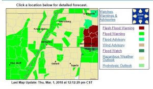
By 2 a.m. Thursday, the National Weather Service said an estimated one to three inches of rain had fallen, prompting the National Weather Service to issue Flash Flood Warnings, Flood Watches and Flood Warnings for multiple counties in the WREG view area.
As of 12:45 p.m., Flood Warnings are still active for several counties, especially those along the Mississippi River.

WREG’s Todd Demers said the river itself is currently higher than what was forecasted. On Thursday, the river was just below 35 feet, which is about a foot higher than a “minor flood stage.” It’s expected to crest on March 9 at 38 feet.
Thankfully, conditions will be improving Thursday evening as a new cold front moves through. It will cool us down into the upper 30s by Friday daybreak.
Sunny skies over the next few days will helps us dry out.
[protected-iframe id=”ca63aae39283bba157688b315302a990-29519520-83897481″ info=”https://www.facebook.com/plugins/video.php?href=https%3A%2F%2Fwww.facebook.com%2Fwreg3%2Fvideos%2F2092685817426780%2F&show_text=0&width=267″ width=”267″ height=”476″ frameborder=”0″ style=”border:none;overflow:hidden” scrolling=”no”]
Drone flight over flooded Sunflower River in Clarksdale:


