MEMPHIS, Tenn. — Snow began falling across the Mid-South Sunday afternoon. It will continue through the evening, before ending in most spots overnight.
Another batch of snow is likely to arrive Monday morning. While the majority of the viewing area will stay all snow, it’s possible that a little sleet gets mixed for some areas in North Mississippi.
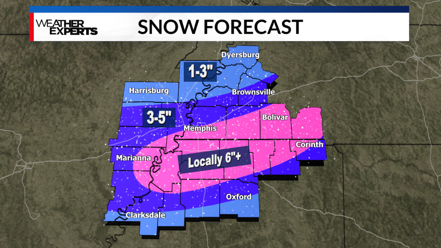
We’re still expecting a heavier band or two to set up south of I-40, resulting in some localized snow totals of 6”+.
Regardless of how much snow you get, we’re all going to be dealing with hazardous travel and dangerously cold air through the first half of this week.
Temperatures on Monday will stay in the teens and low 20s. Monday night however, we plummet into the single digits – with wind chill values below zero. It will be just as cold on Tuesday night.
We aren’t back above the freezing mark in many areas until Thursday. That warmup will be brief before another couple cold days Friday and Saturday. We’ll likely be looking a re-freeze and slick spots in many areas with whatever moisture is still around at that point, but we’ll cross that bridge when we come to it.
*****
All of the Mid-South is under a WINTER STORM WARNING from noon Sunday to 6 a.m. Tuesday.
Snow is starting to fall and may come down heavy at times. 3-5″ of snow is the most likely outcome for the majority of the News Channel 3 coverage area.
Roads are becoming icy Sunday afternoon. Veterans Parkway between Hwy 51 and Navy Road in Millington was closed.
Traffic was backed up going westbound onto the Interstate 55 bridge because at least one tractor-trailer was stalled out on the on-ramp. The Memphis Police Department issued an Inclement Weather Crash Policy alert Sunday afternoon.

The first blast of arctic cold moved into the Mid-South Saturday night. Lows dropped into the teens overnight with wind chills in the single digits.
The University of Memphis closed its campuses at 5 p.m.
Hopefully you wrapped and insulated your pipes before the temperatures dropped overnight. It’s also a good reminder that you can drip facets and open your cabinets as well to help prevent your pipes from freezing over.
Hazardous travel is likely even after the snow ends as temperatures will not get above freezing until at least Thursday afternoon. Temperatures in the single digits Monday and Tuesday night will make for extremely dangerous conditions.
Make sure your pets have a warm place to stay and check on friends and neighbors that may not have adequate heating.
We can not stress enough that regardless of how much snow you get, we are all going to be dealing with hazardous travel and dangerously cold air for the first few days next week.
Download the WREG Weather app to stay up to date with the latest on this upcoming winter weather event.


